A Short Walk That Changes the Whole View
A short observation walk reveals how a path’s turns, trees, and slopes shape what you can see, with a practical method for reading each view.
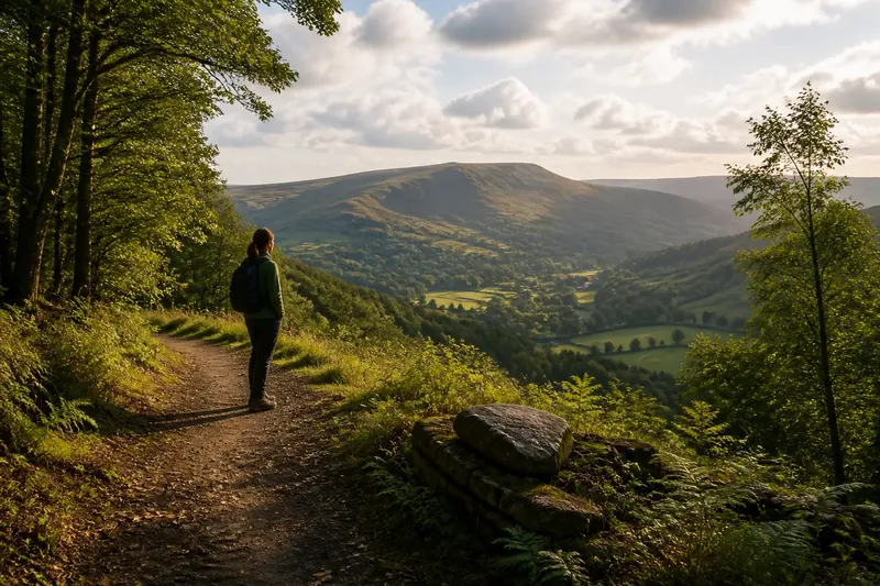
A short observation walk can reveal how a landscape is arranged when you follow one visible feature from its first appearance to the point where it disappears. Choose a safe, permitted path and track the edge of a valley, a band of trees, or a ridge as the terrain and vegetation alternately expose and conceal it. The aim is to understand what shapes the view, not to collect matching scenes from two stops.
What can a path reveal about a landscape?
A path changes the angle from which you see slopes, but its surface and surroundings matter too. A wooded corridor may hide the valley floor, while a nearby opening reveals it; a hillside can keep a distant ridge visible even as nearer ground drops out of sight.
Look for the relationship between foreground, middle distance, and horizon. The foreground includes the ground closest to you, the middle distance often contains a valley or opposing slope, and the horizon is the apparent boundary where land meets sky. When one layer blocks another, the obstruction is part of the evidence, not a gap to fill with guesses.
How do you choose a route that reveals changing sightlines?
Pick a marked route with a safe, comfortable return and a stretch where the surroundings change naturally. A bend, a woodland margin, or a clearing may expose different parts of the same landform without requiring a climb or an unmarked detour.
- Path surface: If the route is firm and level where you plan to pause, follow it; if it is loose, muddy, or uneven, choose another maintained path with a safer stopping place.
- Access and space: If the route has enough room to stop without blocking others or moving off the path, use it; if not, select a wider permitted area.
- Vegetation: If the path passes a natural opening or thinning tree line, observe how the view changes there; if vegetation stays dense, treat the blocked view as useful information rather than pushing through it.
- Terrain: If the path lets you see a slope or valley from a stable position, record the visible contours; if the view requires approaching an edge or unstable ground, stay on the route and choose a safer feature.
- Weather: If cloud and light leave landforms clearly visible, note their effect on contrast; if rain, glare, or poor visibility makes the route harder to use, shorten or postpone the walk.
- Permission: If signs and land-manager directions allow access, continue as planned; if the route is closed or restricted, use an authorized alternative.
For a wheelchair, cane, or other mobility aid, check the route surface, grade, turning space, and rest options with the park or land manager. A change in direction or vegetation can alter a sightline even on level ground, so a hill is not necessary for a useful observation.
How can you read a valley, slope, and horizon?
Start by tracing the visible shape of the land. A valley may appear as a low corridor between rising slopes; a ridge is a long elevated crest; and a spur is a projecting shoulder of a hill. These forms can overlap in a view, so note which one is clearly visible and which is partly hidden.
Then follow the skyline. If a nearer ridge cuts across a distant peak, the nearer land is obscuring part of the farther feature from your position. If a gap opens between the ridges as the path bends, record the gap and the newly visible section, without assuming what lies beyond it.
Vegetation and buildings can also shape a sightline. Trees may conceal a lower slope while leaving its crest exposed, and a wall or roofline may interrupt the view of a valley. Describe the obstruction plainly so your notes distinguish landform from what happens to cover it.
What should you notice as the view changes?
Choose one feature that remains recognizable along the route, such as a distinct ridge, a bend in a stream, or a gap in the skyline. Follow how nearby slopes and foreground cover relate to it, but do not force a comparison if the feature disappears completely.
- Foreground: If trees, a bank, or a building block the lower land, note the obstruction; if the ground is open, describe its slope or surface.
- Valley floor: If you can see the floor, note where it appears between the slopes; if it remains hidden, record that rather than inferring its course.
- Ridge shape: If the skyline forms one continuous crest, describe it that way; if nearer and farther ridges overlap, note where one hides the other.
- Opening or gap: If a break in trees or hills exposes additional land, describe what becomes visible; if the gap reveals only sky or a nearer slope, record that result instead.
- Light and weather: If haze or backlight softens distant features, note the condition; if the skyline stays clear, describe its visible outline without estimating distance.
Keep observation separate from interpretation. “A strip of the valley floor appears below the left slope” reports what you see; “the stream bends behind the trees” describes unseen ground and needs more evidence.
What questions help you interpret a changing view?
Why does a valley appear from one place but not another?
A change in direction may move trees, a nearer slope, or a ridge out of the line of sight. Record which obstruction shifts and which part of the valley becomes visible; do not assume the land itself changed.
Can trees help explain the shape of a slope?
They can show where the visible surface is covered, but they do not reveal the exact ground beneath the canopy. Note where the tree line follows or crosses a slope, and avoid treating the canopy edge as a precise contour.
How should you describe a ridge that hides another ridge?
Write that the nearer ridge obscures part of the farther skyline from your position. If a gap or exposed summit is visible, describe that opening; leave the unseen section unresolved.
What does changing light do to a sightline?
Backlight, haze, and cloud can reduce contrast, making distant land harder to distinguish from the sky. Note the condition alongside the feature, and use “unclear” rather than guessing at its outline.
How can you apply the method on one short walk?
Imagine you are following a permitted park path along the edge of woodland. At the wooded section, you can see a ridge above the trees but not the valley floor; as the path curves toward a clearing, a lower band of land appears beneath the same ridge.
Write “ridge visible above trees” at the wooded section, then “valley floor visible below ridge through clearing” at the opening. The notes support a specific conclusion: the path’s new angle and reduced tree cover opened a sightline to lower ground. They do not establish the exact route of any stream hidden beyond the clearing.
On a short observation walk, the main phrase “short observation walk” describes the method: follow how one landform is revealed or blocked as the path changes. Name the visible feature, the obstruction, and the new opening, then leave unseen ground as an open question. That habit makes a changing view easier to read without stepping beyond what the landscape actually shows.